Environmental Mitigation Projects
The Chatfield Storage Reallocation Project participants have implemented the following on-site and off-site environmental mitigation to address environmental impacts of storing more water in Chatfield Reservoir.
On-site Mitigation
Under the methodology developed in the FR/EIS, the ecological impact of the Chatfield Storage Reallocation Project is measured in “Ecological Function Units” or EFUs. During the FR/EIS, the EFU impacts were projected based primarily on aerial photography. In 2016, the CRMC team completed field verification of the EFU impacts. Environmental mitigation for the impacts of the project are measured in like-kind EFUs – impacted wetland EFUs are replaced with new wetland EFUs; bird EFUs and Preble’s Meadow Jumping Mouse EFUs are handled the same.
The CRMC team includes the EM1 – EFU Technical Experts that completed this field assessment and developed the baseline EFU impacts, reviewed the environmental mitigation designs and projected EFU lift as a result of the mitigation. Ultimately the EM1 team will need to certify the EFU goals for the project have been achieved.
During the EFU field verification, significant degradation on Plum Creek, areas adjacent to the South Platte River, and along Marcy Gulch were identified. In consultation with USACE, a method to predict future degradation in these areas and the long-term benefit of project mitigation to reclaim existing degraded habitat and prevent future degradation was developed.
The EFU methodology and habitat preservation benefits of mitigation are illustrated in the following figure.
PURPOSE AND NEED: Plum Creek is a primary tributary to Chatfield Reservoir encompassing 317-square miles of drainage area upstream of Castle Rock along State Highway 85. Plum Creek is a designated mitigation site for critical and non-critical PMJM habitat, bird habitat, and wetlands.
Urban runoff has resulted in increased channel erosion and sediment deposition in the channel reaches above the Park and severe channel degradation within the Park, resulting in loss of targeted resource habitat due to erosion and lowering of the water table adjacent to the stream. Severe head-cut erosion has progressed rapidly upstream threating existing targeted habitat since finalizing the FR\EIS. The large amount of sediment deposited during the 1965 flood created a sediment delta resulting in multiple channels including the Plum Creek main channel, east and west secondary channels, and secondary sloughs.
ENVIRONMENTAL MITIGATION: The Plum Creek corridor, from the new high water level of the reservoir, upstream approximately 7,000 feet, was stabilized by raising the multiple stream bed and constructing riffle-pool rock structures to control longitudinal grade and planting of riparian and wetland vegetation to control erosion and provide habitat. Other modifications included excavation to establish closer proximity to the water table, micro-topographical grading to emulate natural secondary channels, and seeding and planting in the overbank areas. The Plum Creek trail system was also reconstructed within the reclaimed reach of the Creek.

PURPOSE AND NEED: Sediment loads to the reservoir have a significant impact on water quality. Much of the sediment load to the reservoir is a result of upstream urban runoff and degradation and erosion of the Plum Creek drainage.
ENVIRONMENTAL MITIGATION: The design of the environmental mitigation on Plum Creek included a sediment transport model. This model was used to design the Plum Creek mitigation to raise the channel, stabilize and revegetate the banks to reduce erosion, and reconnect the broader floodplain to restore riparian and wetland habitat. This mitigation is preserving existing high quality habitat along Plum Creek, reclaim PMJM, wetland and bird habitat, and reduce sediment loads to the reservoir.
The following Plum Creek Mitigation rendering includes environmental mitigation information on Sediment Control. Plum Creek is the major source of sediment in Chatfield Reservoir.
As you move around Chatfield Reservoir, please look for the following signs at recreation sites and on kiosks. These signs indicate that assessment and marking of trees is underway.
TREE MANAGEMENT
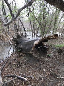
Existing trees within the 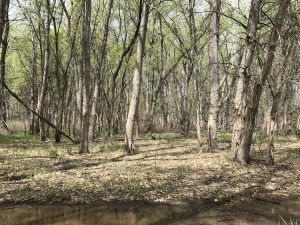 fluctuation zone of Chatfield Reservoir are expected to be impacted as the result of recreation modification construction activities and the increase in water elevation resulting in inundation changes under the proposed reallocation. Dead or unhealthy trees in the fluctuation zone are a potential hazard to boaters, other park visitors, and dam operations.
The FR/EIS originally proposed that all trees below an elevation 5,439 above sea level would be cleared, but Chatfield Reservoir Mitigation Company Inc. (CRMC), in coordination with local experts, Colorado Parks and Wildlife (CPW), and United States Army Corps of Engineers (USACE), determined this would be too destructive to the environment. Therefore, a new approach was proposed and is being taken to manage the trees.
FLUCTUATION ZONE AND ADAPTIVE TREE MANAGEMENT
The objectives of adaptive tree management in the fluctuation zone around Chatfield Reservoir are to:
- Protect visitor safety by removing trees that will be navigation hazards at higher water levels
- Preserve dam safety by removing wood debris that can lodge in the dam outlet
- Conserve as many healthy trees as possible in the fluctuation zone
- Maintain important bird and wildlife habitat
- Remove invasive tree species
The Colorado State Forest Service (CSFS) has conducted an extensive inventory to identify and mark trees for removal or monitoring as the tree management part of the mitigation process. An adaptive tree management plan has been implemented to guide the management objectives.
CSFS will continue to evaluate and mark trees around the reservoir post-inundation. Trees will continue to be marked with blue paint, pink flags, or aluminum tags. Trees marked with blue paint are slated for removal. Trees marked with pink flagging indicate areas that have been or will be evaluated by the CSFS team. Trees marked with aluminum tags will be monitored over time under the objectives of the adaptive tree management plan. CRMC is responsible for engaging qualified experts to evaluate the viability and health of those trees in the future.

Weeds and other nuisance plants thrive in disturbed soils and poorly vegetated areas. Once weeds establish and take over these areas, it is difficult to reclaim these areas with native vegetation. Vegetation management measures will continue in an effort to minimize the number of weeds and other nuisance plants present post-construction.
The herbicides that are used are approved prior to use by Chatfield State Park and the Army Corps of Engineers. The application areas and dates are announced on signs at the Park entrances. The areas that are treated are marked with flagging that have the herbicide sprayed with the associated signal word, and the application date. The application areas are safe to enter when the herbicide is dry, generally within a day of application.
PURPOSE AND NEED: The Adaptive Management Plan (AMP) identified potential change in water quality from expansion of the hypolimnion and inundation of shoreline areas within the reservoir with increased pool levels. Nutrient analysis and water quality modeling performed for the FR/EIS show uncertainty in the potential water quality impacts from increased internal nutrient (i.e., phosphorus) loading due to higher pool levels. To assess potential water quality impacts, water quality modeling is required to address water quality uncertainties, provide input to contingency planning, and facilitate feedback between mitigation monitoring and mitigation actions.
ENVIRONMENTAL MITIGATION: The CRMC has retained a consultant to prepare and update the reservoir model that includes water quality data analysis and evaluation; model selection and development, model calibration and sensitivity analysis, and documentation work tasks. Also, more comprehensive water quality data has been collected since 2014 and will continue throughout the implementation of the CSRP. The model will be updated annually during construction and post-construction periods to assess Project impacts to water quality, if any. If impacts are identified, the reservoir model will assist with identifying management scenarios to correct water quality deficiencies.
PURPOSE AND NEED: The South Platte River is a primary tributary to Chatfield Reservoir with a mountainous watershed of 2600-square miles. The reach of the South Platte River within the Park is a designated mitigation site for critical and non-critical PMJM habitat, bird habitat and wetlands.
During a high runoff event in 2015, erosion occurred in a former oxbow channel of the South Platte adjacent to Titan Lake, a gravel pit created in the 1950’s. This erosion caused a breach of the river into Titan Lake, depositing a large delta of sediment in the lake. The high flows also scoured out the north spillway channel of Titan Lake and dropped the level of the lake by about six feet. Future high flows in the South Platte River pose a high risk of further channel breaches and severe erosion that threaten existing bird, non-critical PMJM, and wetlands habitats, and the mature Cottonwood grove along the channel.
ENVIRONMENTAL MITIGATION: Mitigation activities took place at several locations along the River, including Cigar Lake, the abandoned wetlands, the Southern Oxbow, Willow Creek, Titan Lake, and within the borrow areas. Modifications include excavation to establish closer proximity to the water table, micro-topographical grading to emulate natural secondary channels, and seeding and planting.
To minimize potential for further degradation from bank failures during high flows, mitigation measures included berm construction to direct high flows; grade control structures in the former oxbow channel to prevent the South Platte from changing course; and replacing the outlet structure for Titan Lake to restore water levels in and around the lake. No work occurred within the actual South Platte River channel.

PURPOSE AND NEED: Willow Creek is a small, eastern tributary to the South Platte River discharging into Titan Lake. The area is comprised primarily of upland grasses, with some wetlands and shrubs located to the east along a wetter area adjoining the creek. The area is a designated mitigation site for bird habitat and wetlands.
ENVIRONMENTAL MITIGATION: Modifications include excavation to establish closer proximity to the water table and reconnection of the area as an active floodplain bench for the South Platte River. Drop structures were added to improve channel stability during high-flow storm events. Micro-topographical grading was performed to emulate natural secondary channels, along with seeding and planting to enhance vegetation.
The following South Platte River Mitigation Site rendering includes environmental mitigation information on the Willow Creek On-site Mitigation Site.
EXISTING CONDITION: Titan Lake, located east of the South Platte River across from Cigar Lake, was created during the 1950’s when gravel mining was permitted along the River prior to construction of Chatfield Reservoir. Recreation around the lake is limited to earth trails for pedestrian, biking, and equestrian uses.
High runoff during the summer of 2015 caused the South Platte River to flow into a former oxbow channel adjacent to Titan Lake. The flows from the South Platte River breached the bank of Titan Lake, deposited a large sediment delta that projects into the Lake, and scoured out the north spillway channel of the Lake that dropped the water level about six feet. Another high runoff event could result in greater erosion causing the South Platte River to return to its pre-gravel mining alignment through Titan Lake. If this realignment were to occur, consequences could include dewatering of about 4000 feet of the current South Platte River channel impacting aquatic habitat and mature cottonwoods, and development of a substantial head-cut that could work its way upstream from Titan Lake and perhaps continue up the river.
ENVIRONMENTAL MITIGATION: High earth berms along Titan Lake created by gravel mining activities were graded into a more gently-sloping shoreline using material from the southern oxbow and Willow Creek areas. New shoreline areas were vegetated to enhance habitat for targeted environmental resources. To protect existing habitat in the oxbow and river channel, the existing earth berm is modified to reduce uncontrolled spills from the South Platte River into Titan Lake. In addition, channel structures were provided in the oxbow channel to control the grade and, finally, the outlet from Titan Lake was repaired.
The following South Platte River Mitigation Site rendering includes environmental mitigation information on the Titan Lake Mitigation Site.
EXISTING CONDITION: Cigar Lake, located south of the Gravel Pond, was created during the 1950’s when gravel mining was permitted along the South Platte River prior to construction of Chatfield Reservoir. Recreation around the lake is limited to earth trails for pedestrian, biking, and equestrian uses. Cigar Lake currently has a watermilfoil infestation.
ENVIRONMENTAL MITIGATION: Excavated material from the abandoned wetlands to the west and the north area were used to create new shoreline in Cigar Lake. This material was placed to reinforce several narrow berms between the South Platte River and Cigar Lake that were gradually being scoured by bank erosion and were at risk of being breached by the river. Bank stabilization is reducing the probability of a breach into Cigar Lake to minimize the spread of the invasive plant and loss of existing habitat along the River. New shoreline areas were vegetated to enhance habitat for the target environmental resources.
The following South Platte River Mitigation Site rendering includes environmental mitigation information on the Cigar Lake Mitigation Site.
EXISTING CONDITIONS: Marcy Gulch is an eastern tributary to the South Platte River that meanders through a forest of Cottonwoods and other tree species and confluences into the South Platte River downstream of the reservoir. The lower Gulch is a designated mitigation site for wetlands and bird habitat. Flow in Marcy Gulch is the result of urban runoff and treated effluent from a wastewater treatment plant. Urban runoff threatens the stability of the channel, adjacent wetlands, and the Cottonwood grove.
ENVIRONMENTAL MITIGATION: Following a Technical Advisory Committee recommendation and U.S. Army Corps of Engineers approval, the Marcy Gulch environmental mitigation was deemed not necessary to achieve the necessary EFU credits.

Off-site Mitigation
The FR/EIS identified that, whereas on-site mitigation is preferred, off-site mitigation would be required to fully mitigate for impacted targeted resources and lost Cottonwood trees due to limited on-site opportunities.
The FR/EIS assumed that the vast majority of the environmental mitigation would need to occur off-site, estimating that 711 ecological function units (EFUs) would be required from off-site mitigation. To meet the FR/EIS goal to maximize on-site environmental mitigation to the greatest extent possible, the Chatfield Reservoir Mitigation Company greatly expanded the environmental mitigation on-site along both Plum Creek and the South Platte River to gain PMJM, wetland and bird habitat. As a result, off-site mitigation needs were greatly reduced to only 74 EFUs.
After an exhaustive search, off-site mitigation opportunities for bird habitat within the riparian conservation zone (RCZ) of the main stem Plum Creek and West Plum Creek, were secured through our strong partnership with Douglas County and its Open Space and Natural Resources program.
Description coming soon.
PURPOSE AND NEED: The FR\EIS identified that, whereas onsite mitigation is preferred, that off-site mitigation would be required to fully mitigate for targeted resources and lost Cottonwood trees. The Sugar Creek project, located 19 miles upstream of the Reservoir along 4.5 miles of Douglas County Road 67 within the Pike National Forest, is designated critical habitat unit for the PMJM. Sediment from the gravel road CR67 and adjacent decomposed granite hillside have threatened PMJM habitat and impacted wetlands along Sugar Creek.
ENVIRONMENTAL MITIGATION: Through separate agreements with the USFS and Douglas County, improvements were made to CR67 that include: asphalt paving of a portion of CR67, road embankment and cut-slope stabilization, culvert replacement, small mammal passageways, sediment traps, and ditch erosion control. Habitat enhancement measures were also be made to the Sugar Creek riparian area to provide PMJM habitat. The agreements, both of which have been approved by the parties, also include requirements for maintenance of improvements.