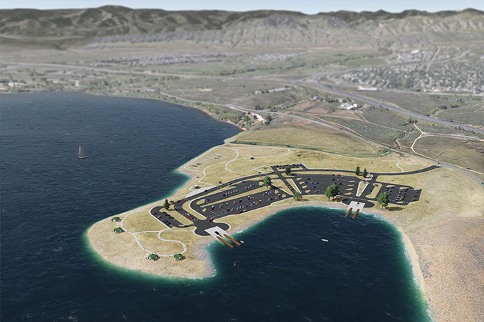
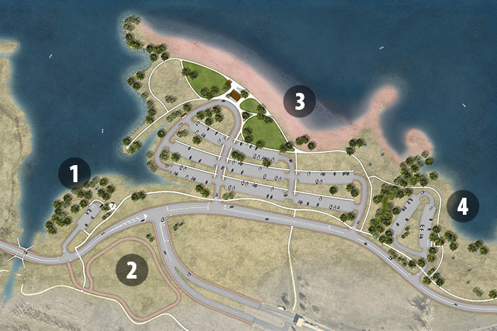
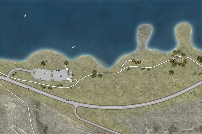
Using this map, you can take a virtual tour of the recreational modification projects planned for Chatfield State Park. Scroll through each area in words, pictures and renderings as you follow the map around the perimeter of the reservoir. Please visit the Construction Updates landing page for updated information on park closures and construction activities.
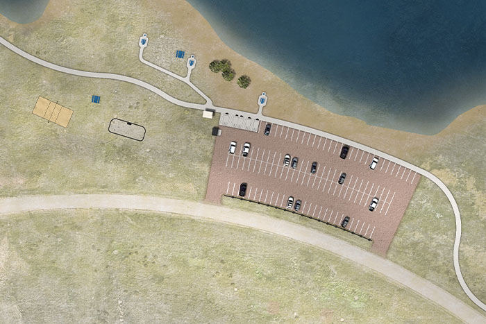
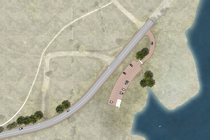
North Boat Ramp
EXISTING FACILITY
North Boat Ramp is a formal boat launch area in the northwest corner of the Reservoir. This area includes two separate boat ramps, each providing ramp lanes and courtesy docks, paved parking, circulation areas, picnic shelters and a variety of site features. Also provided are two ANS boat inspection houses, trash dumpsters, information kiosks, and an ice rescue posts.
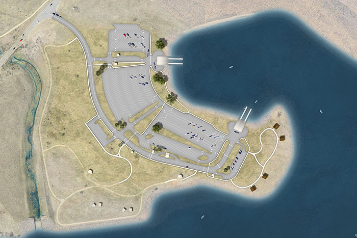
RECREATION MODIFICATIONS
Due to existing site constraints, this site was redeveloped at the existing location with a similar configuration, but at a higher elevation to provide in-kind flood protection. The parking lot size, configuration, lighting, and ancillary features are identical to the existing. The restroom facilities along the west side of the site are not affected by the CSRP Project and are left in their existing condition. The picnic area along with the walks, and trails along the easterly end of the site were reconfigured to adapt to the new grading. Landscape is being restored in a native condition similar to what existed before.
Massey Draw Day Use Area
EXISTING FACILITY
This day use area includes gravel and asphalt trails, a gravel parking lot, a vault toilet, picnic tables with grills, benches, sand volleyball court and horseshoe pits. The site is located on a small plateau between the shoreline and a steep slope offering views of the Reservoir.
RECREATION MODIFICATIONS
The existing parking lot and access drive remains, with the addition of ADA compliant spaces. The existing site configuration is refined by relocating the vault restroom and dumpster to the north end of the parking lot to improve accessibility. The picnic areas and trail were reconfigured to also improve accessibility. Two ADA accessible and six regular picnic tables were provided and the volleyball court and horseshoe pit were replaced. Landscape is being restored in a native condition similar to what existed before.
Eagle Cove Day Use Area
EXISTING FACILITY
The Eagle Cove Day Use area consists of a gravel parking lot and trash dumpster, with no recreation facilities. Although the area has close access to the shoreline, swimming or boat launching is not permitted. Social trails along the shoreline have developed over time.
RECREATION MODIFICATIONS
The gravel parking lot was moved further uphill along with the Park Perimeter Road to provide in-kind flood protection. With the higher water levels in the Reservoir, shoreline access was maintained. All existing recreation features were relocated or replaced in-kind. Three of the existing relocated parking spaces have been designated ADA. Landscape is being restored in a native condition similar to what existed before.
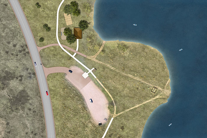
Deer Creek Day Use Area
EXISTING FACILITY
This day use area consists of a paved access road and parking lot, and a picnic area in a riparian setting. Recreation facilities include rest rooms, drinking fountains, picnic tables, grills, benches, trash container, and an information kiosk. A pedestrian bridge across Deer Creek is located nearby.
Native upland grassland dominates the majority of the site, with some widely spaced shade trees and junipers in the vicinity of the parking lot and restroom. Views in this area are unrestricted across the site. Cottonwoods, willows and other riparian and wetland species are established along Deer Creek.
PROJECT MODIFICATIONS
The Perimeter Road was relocated and elevated to provide ln-kind flood protection and access to the Deer Creek Day Use area. The Area was also moved a short distance and located adjacent to the Balloon Launch area. With the higher water levels in the Reservoir and the modifications to the site, there is increased shoreline access from the Deer Creek Day Use Area. New or relocated facilities include a parking lot, picnic tables with grills, trash containers, pedestrian trails, and the Deer Creek pedestrian bridge. Landscape was restored in a native condition similar to what existed before. The linear Cottonwood grove at the shoreline was reestablished at a higher elevation.
Balloon Launch Area
EXISTING FACILITY
This day use area consists of a paved access road and parking lot, and an upland area with trails and pedestrian paths, which are used for launching hot air balloons during special events. Restroom facilities, drinking fountains, picnic tables, grills, benches, trash container, and an information kiosk are located nearby at the Deer Creek DUA.
PROJECT MODIFICATIONS
The Perimeter Road was relocated and elevated to provide in-kind flood protection. The Deer Creek Day Use Area was modified and located adjacent to the Balloon Launch area providing access to restroom facilities, drinking fountains, picnic tables, grills, benches, trash container, and an information kiosk. Existing pedestrian trails were replaced in-kind. Landscape is being restored in a native condition similar to what existed before.
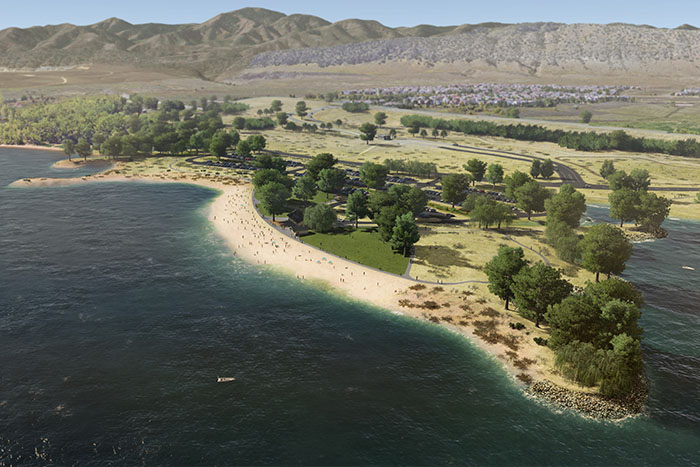
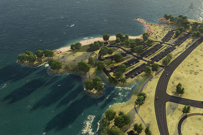
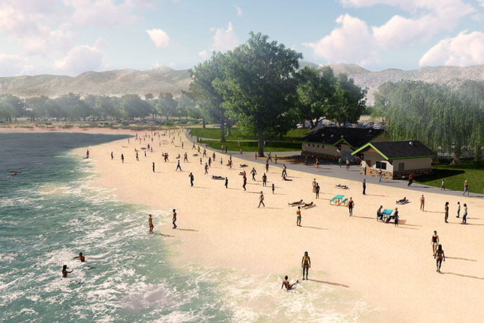
Swim Beach
EXISTING FACILITY
The Swim Beach provides facilities for year-round recreation activities, including swimming and paddle boarding during the summer season, ice fishing and wind sailing during the winter, and picnicking during favorable weather periods. Facilities include: a shower and restroom, first aid station, Park office, concessionaire building, paved parking, picnic tables with grills, benches, portable toilets and an expansive sand beach.
RECREATION MODIFICATIONS
The Swim Beach recreation area and the Park perimeter road were moved to the west and elevated to provide access and In-kind flood protection. Reconfiguration of the Swim Beach area increases available parking, provide more detail to the buildings and sand beach, and improve the connectivity throughout the site. All existing recreation facilities and opportunities were re-established to in-kind level of service, except that the distance from the buildings to the shoreline increased from 130 to 340 feet due to greater fluctuations in the Reservoir water levels, but this also provides more beach area. Landscape is being restored in a native condition similar to what existed before.
Jamison Day Use Area
EXISTING FACILITY
The Jamison Day Use Area includes a paved parking lot, picnic tables, a restroom, vehicle access from the Swim Beach, and multi-use perimeter trail. The vehicular and multi-modal connectivity of the existing Jamison Day Use Area is to the Swim Beach, and the day use area serves as an extension of the Swim Beach.
RECREATION MODIFICATIONS
The Jamison Day Use Area and the Park Perimeter Road were moved further uphill and elevated to provide In-kind flood protection. Vehicle access from the Swim Beach was eliminated and a separate access from the Park Perimeter Road was provided. All existing recreation features are relocated or replaced in-kind. Landscape is being restored in a native condition similar to what existed before.
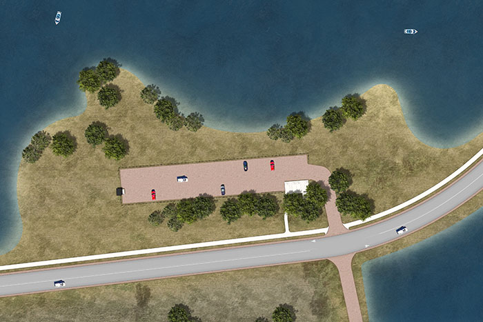
Catfish Flats Day Use Area
EXISTING FACILITY
Catfish Flats Day Use Area consists of a parking lot, a knoll with individual picnic tables, two group-use picnic shelters, multiple small structures, and a restroom. Other facilities include benches, horseshoe pit, and sand volleyball court. The Perimeter Recreation Trail runs along the west edge of the picnic area traverse berms that provide a visual separation between the picnic areas and the Perimeter Road.
RECREATION MODIFICATIONS
The Catfish Flats Day Use Area and the Park Perimeter Road were moved further uphill and elevated to provide In-kind flood protection. The new access drive connects directly to the Perimeter Road. The asphalt parking lot is replaced in-kind with five (5) of the spaces modified for ADA compliance. All existing recreation features were either relocated or replaced In-kind. Landscape is being restored in a native condition similar to what existed before.
Fox Run Day Use Area
EXISTING FACILITY
Fox Run Day Use Area is a group picnic area that consists of a gravel parking lot, portable restrooms, volleyball courts and horseshoe pits, and a group-use picnic shelter. The Perimeter Recreation Trail runs between the parking lot and the shelter.
RECREATION MODIFICATIONS
The Fox Run Day Use Area was redeveloped generally in the same location as the existing facilities. A new access drive is constructed along the same alignment as the existing but regraded to meet the elevation of the new Perimeter Road. The existing gravel parking lot remains, with two (2) of the spaces modified for ADA compliance. The portable restrooms were replaced with vault restrooms. All existing recreation features were either relocated or replaced in-kind. Landscape is being restored in a native condition similar to what existed before.
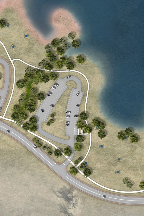
Kingfisher Day Use Area
EXISTING FACILITY
Kingfisher Day Use Area includes a gravel parking lot and shoreline access for fishing and hand-carried boat launching. Other facilities include a dumpster and portable toilet.
RECREATION MODIFICATIONS
The Kingfisher Day Use Area is redeveloped generally in the same location as the existing facilities. A new access drive is constructed adjacent to the existing and re-graded to meet the elevation of the new Perimeter Road. The existing gravel parking lot was raised and rebuilt in-kind to the existing with two (2) of the spaces modified for ADA compliance. The portable toilet was replaced with a vault toilet and a yard hydrant was installed. Landscape is being restored in a native condition similar to what existed before.
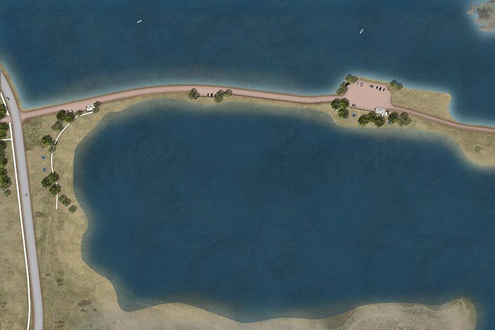
Gravel Pond Day Use Area
EXISTING FACILITY
Gravel Pond Day Use Area is used for swimming, triathlon training and events, nature observation, picnicking, fishing, kayaking, dog training, and scuba training. The area consists of a gravel access road off the Perimeter Road and two parking areas located between the Gravel Pond, the South Platte River, and a second small pond to the east. The parking lot functions as a trailhead for the natural surface trail that runs south. Commercial paddle board rentals are available.
RECREATION MODIFICATIONS
The Gravel Pond was redeveloped generally in the same location as the existing facilities. The access drive is reconstructed along the existing alignment and raised to meet the elevation of the new Perimeter Road. Elevating the Gravel Pond Road also provides In-kind protection from flooding from the South Platte River to preserve water clarity in the Gravel Pond. Two existing gravel parking lots were reconstructed generally in their existing location with a total of five spaces modified for ADA compliance. All recreation features, including picnic tables, benches, and dumpster enclosures were relocated or replaced in-kind. The existing portable toilets were replaced by vault restrooms. Landscape is being restored in a native condition similar to what existed before.
Elevating the Gravel Pond Road also provides In-kind protection from flooding from the South Platte River to preserve water clarity in the Gravel Pond. Two existing gravel parking lots are reconstructed generally in their existing location with a total of five spaces modified for ADA compliance. All recreation features, including picnic tables, benches, and dumpster enclosures will be relocated or replaced In-kind. The existing portable toilets will be replaced by vault restrooms. Landscape will be restored in a native condition similar to what exists today.
Marina - Landside
EXISTING FACILITY
The existing land-side Marina and other associated recreational facilities include: paved circulation roads; parking for boat launching, general recreation users, group sites, and marina employees; bicycle and pedestrian trails (earth and paved) linking the area facilities; portable toilets and restrooms with showers; individual and group picnic areas; boat launching facilities with two ramps, hoist, courtesy dock, ANS inspection station, and vehicle/trailer parking; fenced and paved Marina storage yard with storage sheds; handicap access fishing pier and paved trail from the parking lot; water craft concessionaire; and swimming-prohibited beaches.
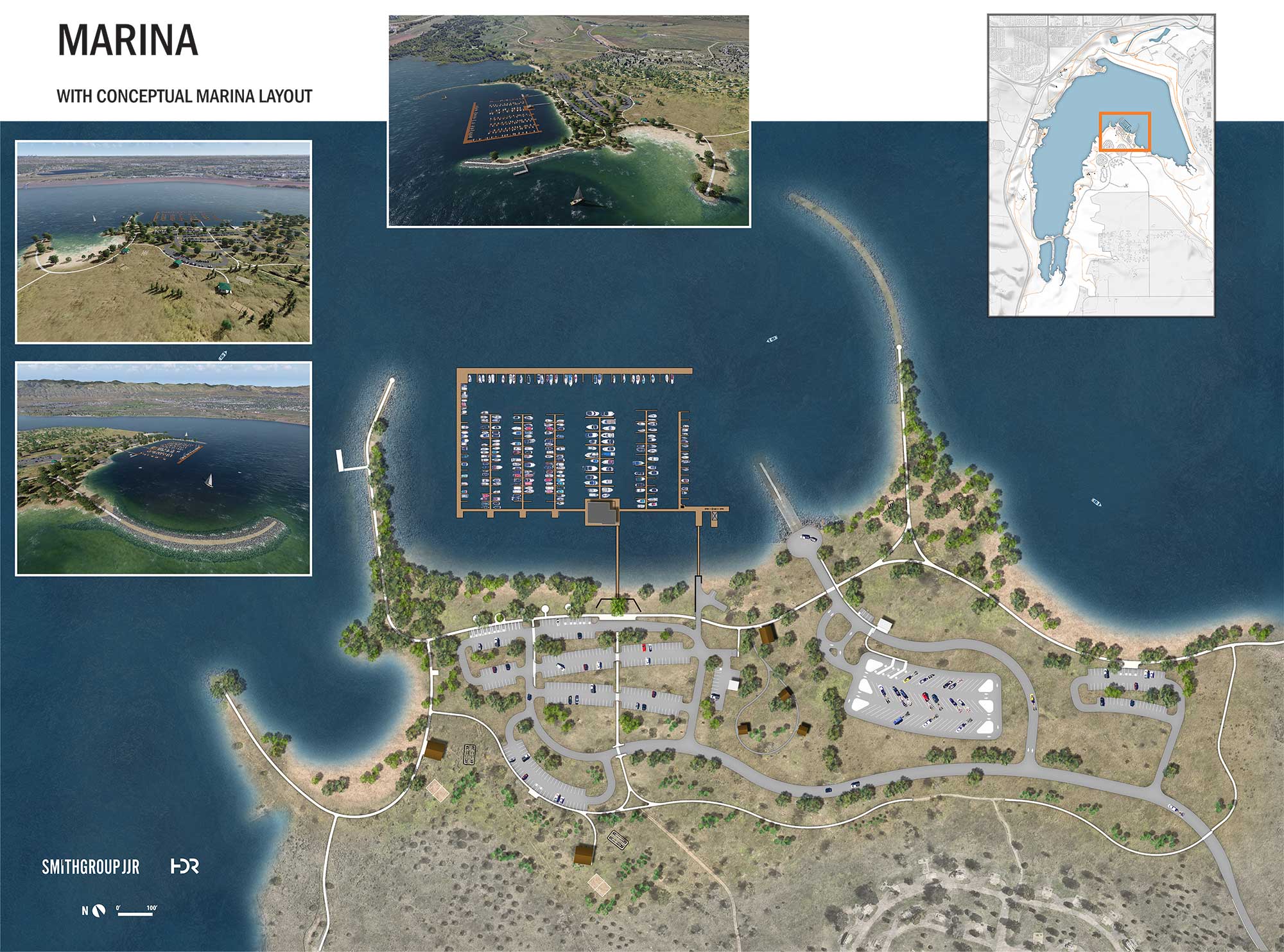
PROPOSED MODIFICATIONS
The land-side portion of the Marina and recreational facilities were moved uphill, elevated to provide flood protection, and relocated or replaced with in-kind facilities. In general, relocated recreation facilities are within the same or similar proximity to each other as existing facilities with some minor modifications to improve functionality. Landscape is being restored in a native condition similar to what existed before.
Marina - Waterside
EXISTING FACILITY
The existing Marina includes secured floating docks with mooring slips of various sizes, dockside utilities, and level of services that are accessible from two gangways from the shore. Services provided include fueling stations with attendant building, sanitary pump-out facilities, courtesy dockage, and picnic areas for slip patrons. A building housing a sit-down restaurant, snack bar services, and offices is available to the general public.
PROPOSED MODIFICATIONS
The waterside facilities at the Marina are replaced with in-kind facilities. The number of boat slips remains the same. Landscape is being restored in a native condition similar to what existed before.
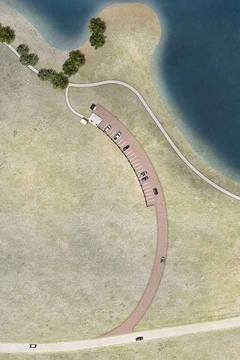
Roxborough Cove
Day Use Area
EXISTING FACILITY
Roxborough Cove Day Use area provides shoreline access to the Reservoir. The area includes a gravel parking lot, a trash dumpster, and a vault restroom.
RECREATION MODIFICATIONS
The gravel parking area has been moved uphill to the southeast, elevated, and located to maintain the proximity to the Reservoir and trails. Two parking spaces were made ADA compliant, the dumpster enclosure relocated, and a new vault restroom constructed. Landscape is being restored in a native condition similar to what existed before.
Plum Creek Day Use Area
EXISTING FACILITY
Plum Creek Day Use Area serves as a trailhead and is located on the southeast side of the Reservoir, just south of Roxborough Cove. The area includes a gravel parking lot, picnic tables with grills, a bench, horseshoe pits, a sand volleyball court, and a vault restroom.
RECREATION MODIFICATIONS
The area has been moved approximately ¼ mile southwest and elevated to provide improved level of flood protection. The gravel parking lot was reconstructed and five parking spaces modified for ADA compliance. All existing recreation features were either relocated or replaced in-kind. One ADA compliant picnic table was provided. Landscape is being restored in a native condition similar to what existed before.